Western Australia is Australia’s most unique destinations that every landscape photographer should include on their bucket list. So many photographers never get to experience this remarkable place, due to its daunting size and distance from the rest of Australia, but that is also part of its appeal. The variety of landscapes in Western Australia is astounding and creates such a diverse range of shots for a landscape portfolio. From the arid deserts that fall into the turquoise waters of Shark bay to the awe-inspiring rock formations of Karijini- it truly is one of the most interesting and unique places in the world. In this blog, I will list about my favourite destinations in Western Australia.
Table of Contents
ToggleThe Bungle Bungles
The Bungle Bungle ranges is where the creativity of nature’s artistry is on full display. It is located within the Purnululu National Park, within the Kimberley region of Western Australia. You do require a 4WD to reach the National Park, as the road is very rough and full of creek crossings, even in the dry season. Alternatively, you can fly here from Kununurra. To get there does require some effort, but the uniqueness of this place is unmatched by anywhere else in the world and it’s absolutely worth the trip.
The most distinctive feature of the Bungle Bungles are the beehive-like sandstone formations. The bands of orange and black are cause by layers of sandstone that have formed over millions of years, with the darker caused by cyanobacteria and the orange bands richly stained with iron and manganese deposits.
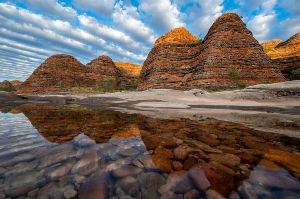
There are a few great locations for capturing the best compositions of the beehive domes. The photo above was taken at the start of Piccaninny creek, which is only a short walk from the main carpark toward the Piccaninny creek lookout. We were incredibly lucky that the previous night had brought storms, and the creeks had filled up with all this beautiful fresh water which made for some great reflection shots. The water was so fresh and transparent that you could see the coloured pebbles laying underneath the creek bed, creating a wonderful foreground.
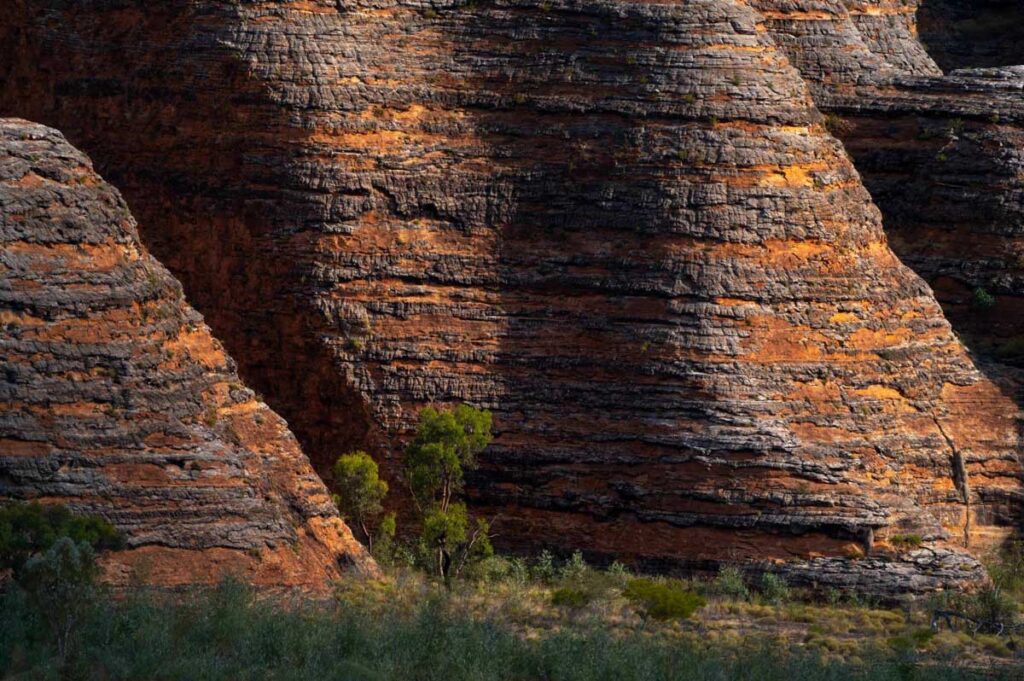
The shot below was taken by a telephoto lens at the Piccaninny Creek Lookout. The photographic compositions of these domes are incredible, and you can really get very creative using different lenses and focal lengths. It’s especially great if you can catch some clouds overhead to create light and shadow on the domes, to really bring out the scale and dimension of these remarkable formations. You can see just how enormous these structures are by comparing them against the full sized gum tree beneath them.

An aerial flight over the Bungle Bungle range is a must-do. You can’t quite fully understand the scale of this national park until you see it from the air. The part that is accessible via the ground is only the ‘tip of the iceberg’ so to speak. The Bungle Bungle Range formation occupies an area of about 450 square kilometres, and you can only begin to fathom how grand this size is from above. I used a 24-70mm lens for all my aerial photography, but a telephoto lens could be interesting to capture some slightly different compositions from above.
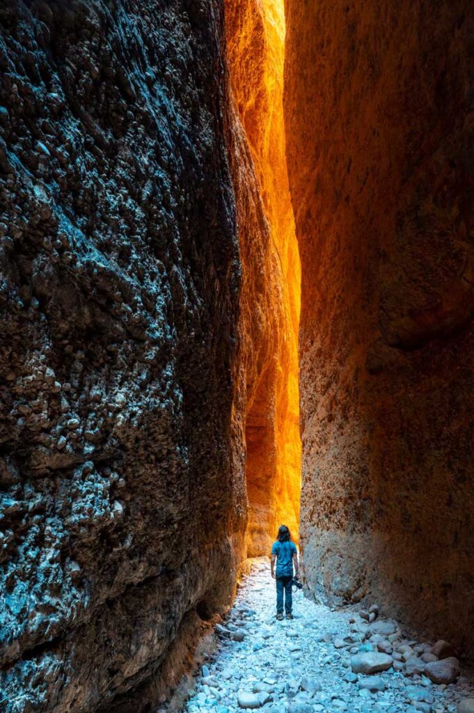
The other excellent photography opportunity within the Bungle Bungles is the Echidna Chasm. It’s very important to get the timing right, as there is only a limited time of the day that the light flows through then roof of the chasm, creating a beautiful orange glow, as it reflects though the rock walls. This time will depend on the time of the year. We arrived at around 11am and the light has already started to fill the crevices, we only had about half an hour of photo shooting time before the sun had moved too far and the whole chasm was in shadow.

Shark Bay
Shark Bay is easily my favourite location for aerial photography. Shark bay is known for its rich red dunes, turquoise waters and its abundance in marine life- including the famous dolphins of Monkey Mia. As a world heritage site, Shark Bay covers 2.2 million hectares on the coast of Western Australia. Its colourful and diverse landscapes are home to a profusion of animals and plants found only in this region. The landscapes of Shark Bay are some of the most spectacular I have come across- very unlike anywhere else on Earth.
When visiting Shark Bay, an aerial flight is a must do! Whether you’re a photographer or not, the only way to truly capture the essence of this region is from above. When I visited, I flew with a company called Shark Bay Aviation. They have a number of scenic flights that routes that cover various parts of region, and will also create custom routes for photographers.
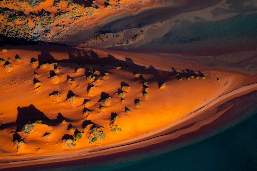
We began our flight by exploring the western side of the island, up toward Cape Peron where you come across these stark red dunes. It is best to start flying as early as possible to catch the morning light on the sand dunes before the shadows become too harsh. I used a combination of a 24-70mm and a 100-400mm lens to capture both the wider landscapes, as well as the abstract telephoto shots. I only had one body and was constantly changing between lenses, so I highly recommend bringing a second camera body if you have one. Alternatively, if you could only bring one lens, I would recommend bringing only the 24-70mm or a lens up to 200mm, as this was where I captured most of my shots. After we visited the red dunes, we continued onto these awe-inspiring red cliffs. I still can’t fathom how captivatingly unique these landscapes are- and so untouched. The stillness of the land is part of the allure of the Shark Bay experience.

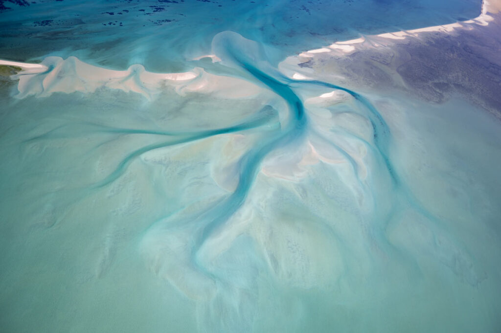
Below is a feature found on the south eastern side of the coastline near Faure Island. I am actually not sure what it is called or whether it even has a name, but I absolutely love the way the deep blue ocean water has crept its way into the surrounding turquoise inlet. There are some great abstract compositions for a telephoto lens in this location as well as the full scale shot as seen below.
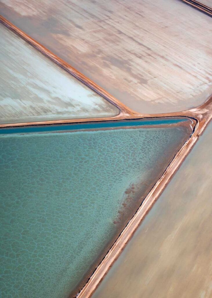
Our scenic flight took us over the Useless Loop salt mines which are massive white salt flats. This is an active mine which was first build in the mid-1960’s. The mine has 37 crystalliser ponds in various shapes and sized and create an array of interesting photographic compositions. There is something about the texture and colour of these salt mines that remind me of an oil painting. It’s hard to believe they are photographs of a real location.

Karijini National park
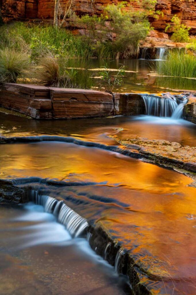
Karijini is a National Park in the Pilbara region of Western Australia about 1,500 kilometres north of Perth and famous for its amazing gorges, slot canyons and towering sheer chasms which are up to 100 metres deep. Canyons can be quite finicky to photograph, as the best timing to visit can be quite varied depending on the canyon. Unlike most other locations, where you can generally predict that sunrise and sunset are going to be the best for lighting, that is not necessarily the case in this instance.
The best way to photograph these canyons is using reflected light. That is what creates the red and orange glow that you can see in the images below. If the sun is too high above, it will just stream directly into the canyon and create a harsh light, but if it’s too low down in the sky, the light won’t even reach inside the canyon and it’ll be too dull. It’s important to find this ‘Goldilocks zone’ which will vary depending on the time of year and the type of canyon, Unfortunately we didn’t get to visit all the canyons, but I would recommend spending more time in two or three of the canyons and be patient to get the right photo than trying to visit them all, if you are restricted for time. Dales Gorge and Joffree Gorge were my favourite to visit for photography. They are both very easily accessible and don’t require any wading through water or waterproof camera bags, unlike Hamersley and Hancock Gorge. However, you do require a fair bit of agility and fitness, as all the hikes require steep climbs, ladders and plenty of walking.
The best part about Karijini National Park is that (like most places in Western Australia)- it’s very quiet. Sure- there is always going to be people around, but given the sheer natural beauty of this place, had this been located in a more accessible region of Australia- it would be teeming with people. The stillness of the region adds to the experience of truly feeling immersed in the desolated Australian Outback.

Sugarloaf Rock

Most of the previous locations are very remote and require some extensive planning to visit from Perth (which is also part of their appeal). Sugarloaf rock on the other hand is much more accessible and still one of my top Western Australian landscape photography locations. It is located in the Leuwinn Naturaliste National Park, just outside of Dunsborough.
As you approach Sugarloaf Rock you will instantly see why this fierce, tooth shaped rock is of interest to photographers from around Australia. With its ocean side often battered by the treacherous Indian Ocean, this location offers some incredible seascape opportunities. Sugarloaf rock is a photographic location that offers ever-changing compositions that I continue to return to whenever I visit Western Australia..
There is a carpark that take you right up to a platform to view Sugarloaf’s remarkable size. For the adventurous, if you walk towards the right side of the platform, there are some great seascape compositions from below where you can capture the ferocious waves crashing against the jagged rocks in the foreground (be careful!) In terms of lighting, the best time would be sunrise as the light will be hitting the rock from behind you. It can be understandably hard to find a composition in the dark, therefore a sunset photo also works quite well as you can see below., especially if you can catch some reflected golden light on the rocks. While Sugarloaf rock is fairly accessible (as far as Western Australia goes), it is still far enough away for any light pollution to affect astrophotography shots. As you can see in the previous photo, it’s possible to capture an abundance of stars and even the Milky Way which can look quite spectacular as a backdrop to this impressive structure

Read More
In the world of hospitality, especially in the age of 2024- captivating images and video of food is absolutely crucial for success. …
Event photography is all about being in the right place at the right time, capturing moments that convey the story and spirit …
Orvieto is a charming and historic town located in the Umbria region of central Italy. Perched atop a volcanic rock cliff, Orvieto …
Hidden away in the rugged West Coast of New Zealand’s South Island, Greymouth is one of the country’s best kept secrets. With …


